ASAP3 - HWRM (2006-2008)
HWRM supports the scientific preparations for the CoReH2O mission (COld REgions Hydrology High-resolution Observatory). CoReH2O has been proposed to ESA by an international team under the lead of ENVEO in response to the 2005 Call for Ideas for the next ESA Earth Explorer Core missions. The mission has been selected by ESA for further technical and scientific studies. CoReH2O addresses the need for improved, spatially detailed measurements of snow and ice from regional to global scales in order to advance the understanding of the role of the cryosphere in the climate system and to improve the knowledge and prediction of water cycle variability and changes in cold environment.
CoReH2O features an innovative sensor, a dual polarized, dual frequency (Ku- and X-band) imaging radar (SAR). These short radar wavelengths are particularly sensitive to physical properties of snow and ice. The main objective of the project HWRM is the development of methods for retrieval of snow and ice parameters from Ku- and X-band SAR measurements.
|
Prime Contractor |
ENVEO IT GmbH |
|
Contract Number |
813923 |
|
In Co-Operation with |
|
Objectives
- developing methods for retrieval of snow and ice parameters from Ku- and X-band SAR measurements;
Project Description
The development work is based on field experiments and theoretical backscatter modelling. Forward models were applied to study the sensitivity of the different frequencies and polarizations for measuring physical properties of snow and ice and to develop concepts for inversion of the radar measurements. Several field campaigns with airborne scatterometer and ground-based SAR were carried out in winter 2006/07 in the Austrian Alps and in Colorado in cooperation with the international project partners.
|
|
||
|
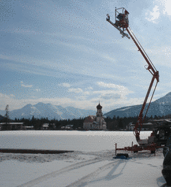
Several field campaigns at two sites including full-polarimetric backscatter measurements at the CoReH2O frequencies X- and Ku-Band using the Ground-based Synthetic Aperture Radar (GB-SAR) system and coincident measurements of snow parameters were carried out in the winter 2006/2007. The data set enables the preparation for snow retrieval algorithms for the CoReH2O mission. The measurements were made in cooperation with University of Cranfield, UK. |
Prototype algorithms for retrieval of snow and ice parameters from high frequency SAR have been developed. Sample snow and ice data products have been produced from airborne test data sets and from satellite-borne scatterometry to demonstrate the performance of the inversion algorithms.
|
|
|
|
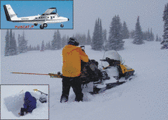
Measurements of physical snow properties at the Rabbit Ears Pass, Colorado, USA, February 2007, carried out within the Cold Land Processes eXperiment CLPX-2 (co-operation with NOHRSC / NOAA and NASA JPL). |
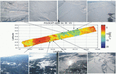
Backscatter image acquired by the airborne imaging Ku-Band scatterometer system POLSCAT developed by NASA / JPL. The image swath is 9 km wide and 90 km long, and covers the region Lake Catamount, in the West of the image over Rabbit Ears Pass to North Park in the Eastern part of the swath. The image shows co-located photographs taken during the POLSCAT acquisitions (with courtesy of NASA / JPL). |
The project results are of great importance for scientific preparation of the CoReH2O mission. The work is also very relevant for improved Earth Observation based services in hydrology and water management of mountain areas and snow covered regions, as addressed by GMES and the climate observing system GCOS. The work at ENVEO deals with the development of methods for the retrieval of snow and glacier parameters from the new SAR data. To support and test these developments, ENVEO participated in field experiments with airborne scatterometry in Austria and Alaska in winter 2007/08. In addition, snow and ice sample products, generated from TerraSAR-X data and scatterometry, are applied in snow hydrology and glacier mass balance models to investigate the information content of the new sensors.


