
ASAP4 - KuX-SAR (2007-2009)
KuX-SAR prepares for the operational and scientific utilization of new high frequency imaging radar missions: the X-band SAR missions TerraSAR-X and COSMO-SkyMed (both launched in June 2007), and the TanDEM-X mission (scheduled for launch in 2009). The project partners are involved in international activities for the new satellites as members of Science Teams and as leaders of AO projects. In addition, the project supports the scientific preparation for the dual frequency (Ku- and X-band SAR) mission CoReH2O, COld REgions Hydrology High-resolution Observatory. CoReH2O was proposed to ESA by an international team under the lead of ENVEO in response to the 2005 Call for Ideas for ESA Earth Explorer Core missions and was selected for the Pre-Phase-A study.
|
Prime Contractor |
ENVEO IT GmbH |
|
Contract Number |
815533 |
|
Partners |
Joanneum Research (JR-DIB), Graz, Austria |
|
In Co-Operation with |
|
Objectives
- using high resolution SAR for snow and ice observations for water management and climate research;
- retrieving forest parameters from high resolution SAR;
Project Description
The work at ENVEO deals with the development of methods for the retrieval of snow and glacier parameters from the new SAR data. To support and test these developments, ENVEO participated in field experiments with airborne scatterometry in Austria and Alaska in winter 2007/08. In addition, snow and ice sample products, generated from TerraSAR-X data and scatterometry, are applied in snow hydrology and glacier mass balance models to investigate the information content of the new sensors.
|
|
||
|
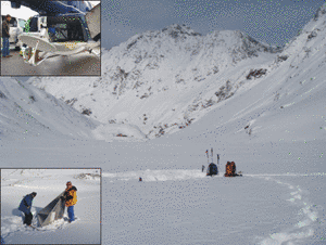
Field campaigns were carried out at several test sites in the Alps of Tyrol in winter 2007/2008 to support the development of snow retrieval algorithms for CoReH2O mission. The measurements include polarimetric measurements of the helicopter based Multi3Scat system at 5 frequencies and coincident measurements of physical snow properties. Trihedral corner reflectors were deployed for absolute calibration of Multi3Scat. The campaigns were performed in co-operation with the University of Hamburg. |
||
|
|
||
|
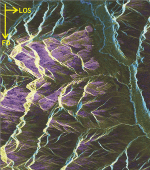
During the Cold Land Processes Experiment 2a TerraSAR-X images, data of the airborne imaging Ku-Band scatterometer POLSCAT and in-situ snow measurements were acquired at three test sites in Alaska in December 2007 and February 2008. The figure shows a TerraSAR-X image of the Chandalar Shelf test site. The different color tones correspond to different polarimetric signatures which are related to different snow pack properties. (TerraSAR-X data provided within TSX AO Project HYD-0096, PI: T. Nagler). |
The work at JR-DIB deals with the development of methods, processing strategies and algorithms for the retrieval of anthropogenic changes on the one hand, and mapping of natural hazards like subsidence or storm damage at a basic level on the other. Therefore, stereo-radargrammetric as well as interferometric mapping techniques are adapted and tuned with respect to the characteristics of the high-resolution TerraSAR-X data. For these data, semi-automated mapping procedures and concepts for end-to-end processing lines are expected to become readily available by this project.
|
|
||
|
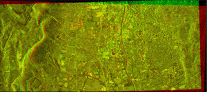
Anaglyph presentation of TerraSAR-X stereo images acquired in Spotlight mode, showing urban/sub-urban areas of the city of Graz. |
|
|
|
|
||
|
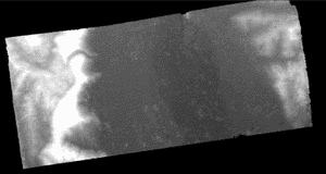
Very first surface model of urban/sub-urban areas of the city of Graz, as generated stereoscopically from a triplet of TerraSAR-X Spotlight image data. |
The synergy in the methods for SAR data processing for the two applications addressed by ENVEO and JR-DIB, is exploited by joint methodological developments. The project achievements related to forest parameter retrieval support pan European and regional assessment of forest distribution and condition with respect to GMES Core Services in GEOLAND 2 and future Downstream Services. The snow and ice component is very relevant for global cryosphere monitoring in the proposed GMES Core Service on Climate Change and for Downstream Services in water management and hydrology.